Environment
Starting from the historic market town of Malmesbury the White Walls Way is a twenty-mile circular trail through the beautiful countryside of the Cotswolds Area of Outstanding Beauty. The trail passes through tranquil woods, rolling farmland, broad open common land, and across the beginnings of the Bristol Avon.
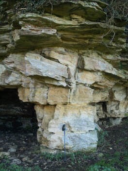
The underlying geology of the area and the effects of the last ice-age contribute to a gently rolling terrain. The distinctive limestone found in the area leads to a landscape with many examples of drystone walls and pretty Cotswold stone cottages.
Along the route the variety of habitats and the quietness of the trail give you the opportunity to see a wide range of wildlife. Keep an eye out for kingfishers, hares, deer, buzzards, kestrels, and red kites, among many others.
Geology
As you walk the White Walls Way from Malmesbury to Luckington you will be walking entirely on rocks of the middle Jurassic period, laid down around 160-165 million years ago. At this time, the underlying rock of what was to form the Malmesbury district was a lot further south than it is now - about 30N, roughly the latitude the Canary Islands are today. It was part way through a long erratic journey north from near the South Pole, where it had been 330 million years earlier, borne by moving tectonic plates – a journey that continues today...
|
Discover the story of the ground you are walking on. Richard Skeffington, Professor of Physical Geography at the University of Reading guides you through the geology of the White Walls way. Read the full story... |
About us
The White Walls Way has been developed by Malmesbury Area Pathfinders (MAP), with funding from the Steve Cox Mayoral Fund, Malmesbury Carnival, and Wiltshire Council's Malmesbury Area Board. MAP is a community group dedicated to promoting walking in North-West Wiltshire.
MAP is part of MVCAP, a registered community charity (Reg: 1155592) based in Malmesbury, Wiltshire, UK.
(c) 2021 MVCAP
MAP is part of MVCAP, a registered community charity (Reg: 1155592) based in Malmesbury, Wiltshire, UK.
(c) 2021 MVCAP

|
|

|

|
