Welcome to the White Walls WayStarting from the historic market town of Malmesbury the White Walls Way is a twenty-mile circular trail consisting of 7 stages. Each stage can be walked in 1-2 hours and several stages can be easily reached using local bus services. There are several pubs along the way and Malmesbury, Sherston, and Luckington have local shops selling food and drinks.
|

|
|
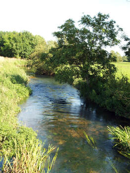
BeautyThe White Walls Way winds its way through the beautiful countryside of the Cotswolds Area of Outstanding Beauty. The trail passes through tranquil woods, rolling farmland, pretty Cotswold villages, broad open common land, and across the beginnings of the Bristol Avon.
|
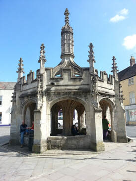
HistoryThe White Walls Way passes through rolling Cotswold countryside which is full of evidence of human activities across the ages. Iron-age, Roman, and Saxon settlements; the last-resting place of the first king of England; medieval Churches; civil war battlescars; Georgian architecture; Victorian industry; and the legacy of two world wars - all this and more can be found along the route.
The trail is named after the site of a Roman town known as 'Whitewalls'. The remains and more information about the site can be found about halfway along the route of Stage 6. |
|
|
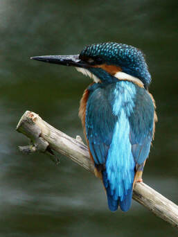
NatureAlong the White Walls Way the variety of habitats and the quietness of the trail give you the opportunity to see a wide range of wildlife. Kingfishers, hares, deer, buzzards, kestrels, and red kites are often encountered along the route.
|
About us
The White Walls Way has been developed by Malmesbury Area Pathfinders (MAP), with funding from the Steve Cox Mayoral Fund, Malmesbury Carnival, and Wiltshire Council's Malmesbury Area Board. MAP is a community group dedicated to promoting walking in North-West Wiltshire.
MAP is part of MVCAP, a registered community charity (Reg: 1155592) based in Malmesbury, Wiltshire, UK.
(c) 2021 MVCAP
MAP is part of MVCAP, a registered community charity (Reg: 1155592) based in Malmesbury, Wiltshire, UK.
(c) 2021 MVCAP

|
|

|

|
